New 1981-2010 Averages being used this year.
Note: This publication is currently undergoing major revisions. The current publication will be replaced with a new publication based on stakeholder requirements and scientific advances. We expect to begin sharing details on this soon. If you have input on content, format, or publication frequency at any time, please contact us at cbrfc.webmasters@noaa.gov.Green Water Supply Outlook, February 1, 2012

Green Water Supply Outlook, February 1, 2012


Prepared by Ashley Nielson
NOAA, National Weather Service
Colorado Basin River Forecast Center
Salt Lake City, Utah
www.cbrfc.noaa.gov

Contents

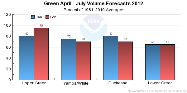
Green Summary


*Median of forecasts within each basin.


Upper Green Basin Conditions

The following conditions influenced this month's forecasts:

Precipitation:
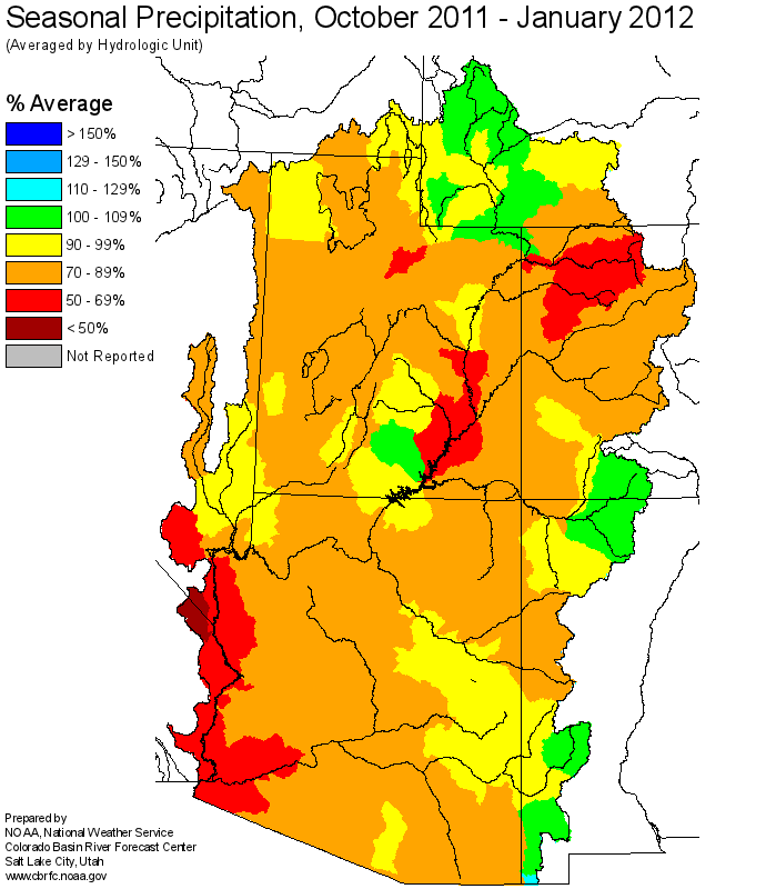
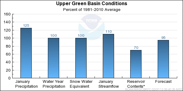
Seasonal October through January precipitation was 100 percent of average in the Upper Green basin. January precipitation was 125 percent of average.

Snow:
February 1st snow water equivalent was 100 percent of average in the basin.
--- Upper Green basin snow water equivalent plot.

Streamflow:
January streamflow was near 110 percent of average.

Soil Moisture:
Modeled soil moisture states indicated near average to above average soil moisture conditions last fall prior to snow accumulation.

Climate Forecasts:
Climate forecasts were not a factor because there is not a strong correlation between La Nina conditions and winter precipitation in the Upper Green basin.

Forecast Summary:
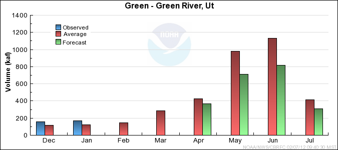
Seasonal precipitation in the Upper Green remains near average as a result of above average and much above average precipitation in October, November, and January. Snow water equivalent has increased from below average on January 1 to near average due to the above average precipitation in January. It is also important to note that fall soil moisture conditions were near to above average. As a result, current April through July streamflow volume forecasts increased by 15 to 20 percent and range between 74 and 100 percent of average with a median value of 94 percent.


* Percent usable capacity, not percent average contents.
Click for multi-month Graph.

Yampa/White Basin Conditions

The following conditions influenced this month's forecasts:

Precipitation:
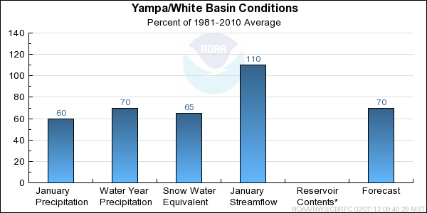
Seasonal October through January precipitation was 70 percent of average in the Yampa/White basin. January precipitation was near 60 percent of average.

Snow:
February 1st snow water equivalent was 65 percent of average in the basin.
--- Yampa basin snow water equivalent plot.

Streamflow:
January streamflow ranged between 110 and 120 percent of average.

Soil Moisture:
Modeled soil moisture states indicated above average to much above average soil moisture conditions last fall prior to snow accumulation.

Climate Forecasts:
Climate forecasts were not a factor in the forecasts because there is not a strong correlation between La Nina conditions and winter precipitation in the Yampa/White basin.

Forecast Summary:
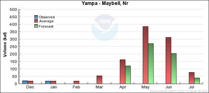
January precipitation was much below average in the Yampa/White basins. As a result of much below average conditions for both December and January, both seasonal precipitation and snow water equivalent are much below average. It is also important to note that fall soil moisture conditions were above to much above average. As a result of another below average month, current April through July streamflow volume forecasts have decreased by 5 to 10 percent and now range between 62 and 79 percent of average with a median value of 70 percent. Forecasts are slightly higher than current snow conditions might suggest due to wet antecedent conditions.


* Percent usable capacity, not percent average contents.
Click for multi-month Graph.

Duchesne Basin Conditions

The following conditions influenced this month's forecasts:

Precipitation:
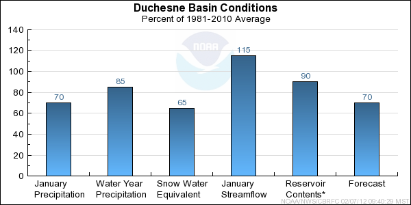
Seasonal October through January precipitation was 85 percent of average in the Duchesne basin. January precipitation was 70 percent of average.

Snow:
February 1st snow water equivalent was 65 percent of average in the basin.
--- Duchesne basin snow water equivalent plot.

Streamflow:
December streamflow was 115 percent of average.

Soil Moisture:
Modeled soil moisture states indicated much above average soil moisture conditions last fall prior to snow accumulation.

Climate Forecasts:
Climate forecasts were not a factor in the forecasts because there is not a strong correlation between La Nina conditions and winter precipitation in the Duchesne basin.

Forecast Summary:
Seasonal precipitation in the Duchesne is below average as a result of much below average and below average conditions in December and January. Snow water equivalent is also much below average for the majority of the basin. However, it is important to note that fall precipitation and soil moisture conditions were much above average. Wet antecedent conditions are resulting in somewhat higher forecasts for the Whiterocks and Uinta river basins. As a result, current April through July streamflow volume forecasts have decreased by 5 to 10 percent and range between 54 and 93 percent of average with a median value of 69 percent. Forecasts are slightly higher than current snow conditions might suggest due to wet antecedent conditions.


* Percent usable capacity, not percent average contents.
Click for multi-month Graph.

Lower Green Basin Conditions

The following conditions influenced this month's forecasts:

Precipitation:
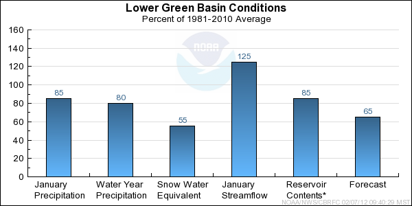
Seasonal October through January precipitation was 80 percent of average in the Lower Green basin. January precipitation was 85 percent of average.

Snow:
February 1st snow water equivalent was 55 percent of average in the basin.
--- Lower Green basin snow water equivalent plot.

Streamflow:
January streamflow ranged from 120 to 130 percent of average.

Soil Moisture:
Modeled soil moisture states indicated near average to above average soil moisture conditions last fall prior to snow accumulation.

Climate Forecasts:
Climate forecasts were not a factor in the forecasts because there is not a strong correlation between La Nina conditions and winter precipitation in the Lower Green basin.

Forecast Summary:
Seasonal precipitation is below average and snow water equivalent is much below average in the Lower Green due to below average monthly precipitation in November, December, and January. It is also important to note the fall soil moisture conditions were near to above average. As a result, current April through July streamflow volume forecasts remain similar to January 1 and range between 56 and 75 percent of average with a median value of 65 percent.


* Percent usable capacity, not percent average contents.
Click for multi-month Graph.


Upper Green Specific Site Forecasts (kaf)

Click site name for graph.
Forecast
Period
90%
Exceedance
Volume
50%
Exceedance
Volume
Percent
Average
10%
Exceedance
Volume
Green
Daniel, Nr, Warren Bridge, At April-July18223596295
Pine Ck
Fremont Lk, Abv April-July809698114
New Fork
Big Piney, Nr April-July24535099475
Green
Fontenelle Res, Fontenelle Nr April-July405685941040
Big Sandy
Farson, Nr April-July36519872
Green
Green River, Wy, Nr April-July43069595960
Hams Fork
Frontier, Nr, Pole Ck, Blo April-July25458371
Viva Naughton Res April-July355980100
Blacks Fork
Robertson, Nr April-July457079100
Ef Smiths Fork
Stateline Res, Robertson,nr April-July11.5207431
Green
Flaming Gorge Res, Flaming Gorge Dam, At April-July500880901370


Yampa/White Specific Site Forecasts (kaf)

Click site name for graph.
Forecast
Period
90%
Exceedance
Volume
50%
Exceedance
Volume
Percent
Average
10%
Exceedance
Volume
Yampa
Stagecoach Rsvr, Abv April-July8.4167027
Steamboat Springs April-July12318069250
Elk
Milner, Nr April-July13723573315
Elkhead Ck
Long Gulch, Abv, Hayden, Nr April-July19.9456280
Yampa
Maybell, Nr April-July35063568985
Little Snake
Slater, Nr April-July7311071155
Savery, Nr April-July13923066345
Lily, Nr April-July13024070370
White
Meeker, Nr April-July13521075330
Watson, Nr April-July14022079310


Duchesne Specific Site Forecasts (kaf)

Click site name for graph.
Forecast
Period
90%
Exceedance
Volume
50%
Exceedance
Volume
Percent
Average
10%
Exceedance
Volume
Big Brush Ck
Vernal, Nr, Red Fleet Res, Abv April-July9.7167624
Ashley Ck
Vernal, Nr April-July19.8357055
West Fork Duchesne
Vat Diversion, Blo April-July6.2126519.6
Duchesne
Tabiona, Nr April-July447368109
Rock Ck
Upper Stillwater Res April-July38557475
Mountain Home, Nr April-July45657489
Currant Ck
Currant Ck Res April-July3.3105118
Strawberry
Solider Springs,nr April-July11.9305456
Starvation Res, Duchesne, Nr April-July246054115
Duchesne
Duchesne, Nr, Knight Div, Abv April-July8613570194
Lake Fork
Moon Lake Res, Mtn Home, Nr April-July36527971
Yellowstone
Altonah, Nr April-July32498070
Whiterocks
Whiterocks, Nr April-July31509374
Uinta
Neola, Nr April-July406689100
Duchesne
Myton April-July8020063375
Randlett, Nr April-July10024064490


Lower Green Specific Site Forecasts (kaf)

Click site name for graph.
Forecast
Period
90%
Exceedance
Volume
50%
Exceedance
Volume
Percent
Average
10%
Exceedance
Volume
White
Blo Tabbyune Ck, Soldier Summit, Nr April-July5.3106516.2
Fish Ck
Scofield, Nr, Reservoir, Abv April-July4.5206736
Price
Scofield Res, Scofield, Nr April-July15.8276643
Green
Green River, Ut April-July11702200753560
Huntington Ck
Electric Lake April-July3.87.55612.4
Power Plant, Blo April-July13.3266243
Seeley Ck
Joes Vly Res, Orangeville, Nr April-July17.5335953
Ferron Ck
Ferron, Nr April-July16.4277140
Muddy Ck
Emery, Nr April-July6.1126019.9

Differences between the full period forecasts and the residual forecasts may not exactly equal the actual observed volumes due to rounding conventions (see Definitions section).

Reservoir Monthly Inflow Forecasts
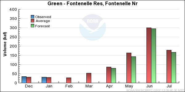


Green End of Month Reservoir Contents (kaf)

Usable
Capacity
EOM
Contents
Percent
Usable
Capacity
Last Year
EOM
Last Year
%Capacity
untitled Green
Fontenelle Res, Fontenelle Nr 344.8 207.4 60 210.0 61
Flaming Gorge Res, Flaming Gorge Dam, At 3752.0 3403.7 91 3111.4 83
untitled Strawberry
Solider Springs,nr 1105.9 978.7 88 975.1 88
Starvation Res, Duchesne, Nr 165.3 142.1 86 141.9 86
untitled Price
Scofield Res, Scofield, Nr 65.8 48.9 74 22.7 34
untitled Seeley Ck
Joes Vly Res, Orangeville, Nr 61.6 46.8 76 41.3 67
untitled Huntington North Reservoir Storage
4.2 3.7 87 2.0 46
untitled
TOTAL 5499.6 4831.3 88 4504.3 82

Monthly Streamflows


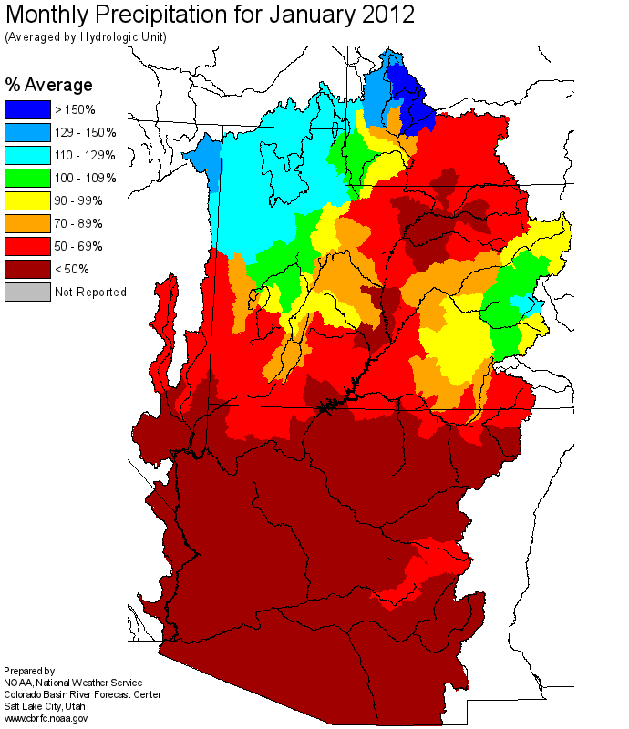
Precipitation Maps


Definitions

10% exceedance forecast: Given the current hydrometeorological conditions, i.e current snowpack, soil moisture and streamflow, the volume that has a 10% chance of being exceeded. Previously referred to as "Reasonable Maximum Forecast".

50% exceedance forecast: Given the current hydrometeorological conditions, i.e current snowpack, soil moisture and streamflow, the volume that has a 50% chance of being exceeded. Previously referred to as "Most Probable Forecast".

90% exceedance forecast: Given the current hydrometeorological conditions, i.e current snowpack, soil moisture and streamflow, the volume that has a 90% chance of being exceeded. Previously referred to as "Reasonable Minimum Forecast".

Acre-Foot (af): The volume equal to one acre covered one foot deep (43,560 cubic feet). See kaf below.

Average: The arithmetic mean. The sum of the values divided by the number of values. Values from 1981-2010 are used for this publication.

Categories: Much Above Average=Greater than 130%, Above Average=111-130%, Near Average=90-110%, Below Average=70-89%, Much Below Average=Less than 70%.

CBRFC: Colorado Basin River Forecast Center.

Forecast Period: The period from April 1 through July 31, unless otherwise noted.

kaf: Thousand Acre-Feet. See Acre-Foot above.

Inflow: The volume of water that flows into a reservoir or lake.

Median: The middle value of an ordered set of values. Half of the values are higher and half of the values are lower. When the set contains an even number of values the median is the average of the two middle numbers.

NOAA: National Oceanic and Atomospheric Administration.

NWS: National Weather Service.

Rounding Conventions:
RangeRound to
0-1.990.01
2.0-19.90.1
20-1991.0
200-9995.0
1000+3 significant digits


Streamflow: The volume of water that flows past a specific stream site.

Water Year: The 12-month period, October 1 through September 30. The water year is designated by the calendar year in which it ends. Thus, the year ending September 30, 2008, is called the "2008 water year."


Additional Information

Water supply forecasts take into consideration present hydrometeorological conditions and use average basin temperatures and precipitation for the forecast period. As the forecast season progresses, a greater portion of the future hydrologic and climatic uncertainty becomes known and monthly forecasts become more accurate. For more information on the tools we use, consult Water Supply Forecasting Tools.

Volume forecasts represent adjusted flows; that is, observed flows with upstream water use taken into account. Adjusted flows will closely approximate natural or unimpaired flows. However, not all upstream diversions or impoundments are measured or quantifiable. For specific adjustments used with each forecast point, consult the Guide to Water Supply Forecasting.

The Water Supply Outlook is issued monthly January through May by the Colorado Basin River Forecast Center. It represents a coordinated effort between the National Weather Service, Natural Resources Conservation Service, Bureau of Reclamation, U.S. Geological Survey and local water district managers.

Note: Data used in this report are provisional and are subject to revision.

For more information, or to be included on the mailing list, please contact:

Colorado Basin River Forecast Center
2242 W North Temple
Salt Lake City, UT 84116
(801) 524-5130
www.cbrfc.noaa.gov


Hydrologist: Ashley Nielson