Note: This publication is currently undergoing major revisions. The current publication will be replaced with a new publication based on stakeholder requirements and scientific advances. We expect to begin sharing details on this soon. If you have input on content, format, or publication frequency at any time, please contact us at cbrfc.webmasters@noaa.gov.Green Water Supply Outlook, June 1, 2010

Green Water Supply Outlook, June 1, 2010


Prepared by William Reed
NOAA, National Weather Service
Colorado Basin River Forecast Center
Salt Lake City, Utah
www.cbrfc.noaa.gov

Contents

Green Summary


*Median of forecasts within each basin.


Upper Green Basin Conditions

The following conditions influenced this month's forecasts:

Precipitation:
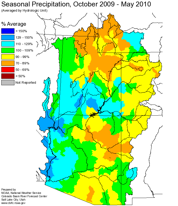
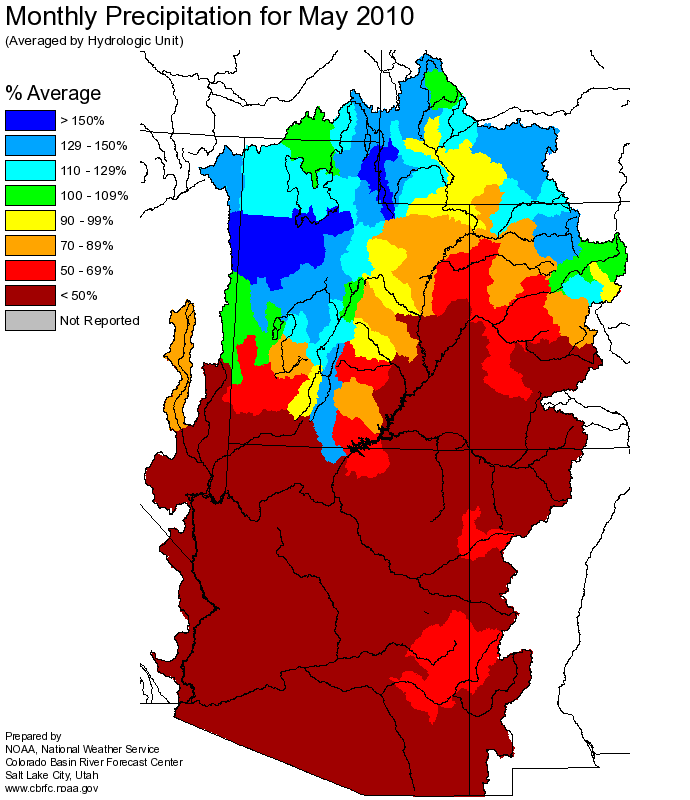
Seasonal October through May precipitation was 90 percent of average in the Upper Green basin. May precipitation was 120 percent of average.

Snow:
On June 1st, the basinwide snowpack was 95 percent of average. However, the upper part of the basin, above 10,000 feet in elevation, is not gaged. The water year snowpack peaked on April 15th at much below the average peak.
--- Upper Green basin snow water equivalent plot.

Streamflow:
May streamflow was near 20 percent of average.

Soil Moisture:
Modeled soil moisture states ranged from below average to near average heading into the winter.

Climate Forecasts:
Climate forecasts were not a factor because there is not a strong correlation between El Nino conditions and winter precipitation in the Upper Green basin.

Forecast Summary:
Due primarily to the much below average water year peak snowpack, the April through July streamflow volume forecasts are much below average. These forecasts range between 47 and 73 percent of average, with a median value of 55 percent. The June through July streamflow volume forecasts range between 54 and 82 percent of average, with a median value of 60 percent.
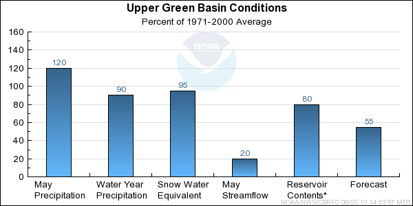


* Percent usable capacity, not percent average contents.
Click for multi-month Graph.

Yampa/White Basin Conditions

The following conditions influenced this month's forecasts:

Precipitation:
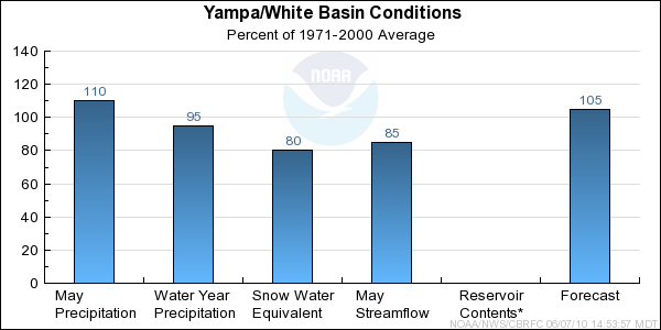
Seasonal October through May precipitation was 95 percent of average in the Yampa/White basin. May precipitation was 110 percent of average.

Snow:
June 1st snow water equivalent was 80 percent of average in the basin as a whole. The seasonal snowpack peaked on April 10th at 80 percent of the average peak. This year cooler temperatures retained some of the snowpack later into the season.
--- Yampa basin snow water equivalent plot.

Streamflow:
May streamflow was near 85 percent of average.

Soil Moisture:
Modeled soil moisture states were near average heading into the winter for the Little Snake and White River basins. Modeled states ranged from below average to near average heading into winter for the Yampa basin.

Climate Forecasts:
Climate forecasts were not a factor because there is not a strong correlation between El Nino conditions and winter precipitation in the Yampa/White basin.

Forecast Summary:
Due to the near average precipitation to date, and because some of the snowpack was retained later into the season because of cooler temperatures, the April through July streamflow volume forecasts are near average at this time. These forecasts range between 54 and 128 percent of average, with a median value of 105 percent. The June through July streamflow volume forecasts range between 51 and 115 percent of average, with a median value of 80 percent.


* Percent usable capacity, not percent average contents.
Click for multi-month Graph.

Duchesne Basin Conditions

The following conditions influenced this month's forecasts:

Precipitation:
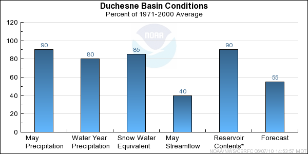
Seasonal October through May precipitation was 80 percent of average in the Duchesne basin. May precipitation was 90 percent of average.

Snow:
June 1st snow water equivalent was 85 percent of average in the basin as a whole.
--- Duchesne basin snow water equivalent plot.

Streamflow:
May streamflow was near 40 percent of average.

Soil Moisture:
Modeled soil moisture states were much below average to below average heading into the winter.

Climate Forecasts:
Climate forecasts were not a factor because there is not a strong correlation between El Nino conditions and winter precipitation in the Duchesne basin.

Forecast Summary:
Due to below average water year precipitation, below average seasonal snowpack, and much below average soil moisture heading into winter, the April through July streamflow volume forecasts continue to be much below average. These forecasts range between 34 and 76 percent of average, with a median value of 55 percent. The June through July streamflow volume forecasts range between 25 and 73 percent of average, with a median value of 65 percent.


* Percent usable capacity, not percent average contents.
Click for multi-month Graph.

Lower Green Basin Conditions

The following conditions influenced this month's forecasts:

Precipitation:
Seasonal October through May precipitation was 95 percent of average in the headwaters of the Lower Green basin. May precipitation was 90 percent of average.

Snow:
June 1st snow water equivalent was 50 percent of average in the Price and San Rafael basin. Elsewhere within the Lower Green the snow was essentially depleted.
--- Price basin snow water equivalent plot.

Streamflow:
May streamflow was near 50 percent of average.

Soil Moisture:
Modeled soil moisture states were much below average heading into the winter.

Climate Forecasts:
Climate forecasts were not a factor because there is not a strong correlation between El Nino conditions and winter precipitation in the Lower Green basin.

Forecast Summary:
Due to the below average seasonal snowpack, and the much below average soil moisture heading into winter, the April through July streamflow volume forecasts continue to be much below average. These forecasts range between 32 and 61 percent of average, with a median value of 45 percent. The June through July streamflow volume forecasts range between 45 and 65 percent of average, with a median value of 50 percent.


* Percent usable capacity, not percent average contents.
Click for multi-month Graph.


Upper Green Specific Site Forecasts (kaf)

Click site name for graph.
Forecast
Period
90%
Exceedance
Volume
50%
Exceedance
Volume
Percent
Average
10%
Exceedance
Volume
Green
Daniel, Nr, Warren Bridge, At April-July12414655170
June-July9311561139
Pine Ck
Fremont Lk, Abv April-July45585672
June-July34475661
New Fork
Big Piney, Nr April-July16321053265
June-July13318061235
Green
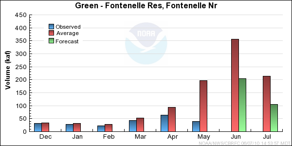
Fontenelle Res, Fontenelle Nr April-July31541048520
June-July21531054420
Big Sandy
Farson, Nr April-July24335744
June-July15246235
Green
Green River, Wy, Nr April-July30541547550
Hams Fork
Frontier, Nr, Pole Ck, Blo April-July31385846
June-July14.3216629
Viva Naughton Res April-July40505664
June-July14.2256839
Blacks Fork
Robertson, Nr April-July55697385
June-July41558271
Ef Smiths Fork
Robertson, Nr April-July15.2217228
June-July10.716.57924
Green
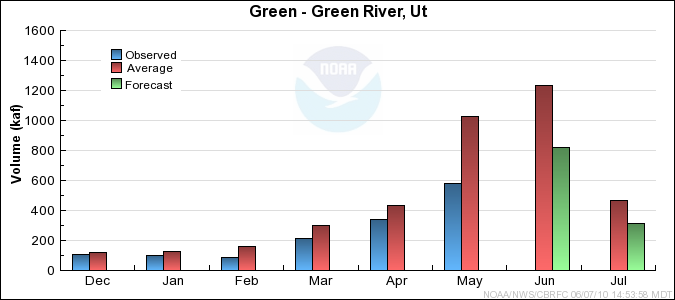
Flaming Gorge Res, Flaming Gorge Dam, At April-July41557548770
June-July25041056605


Yampa/White Specific Site Forecasts (kaf)

Click site name for graph.
Forecast
Period
90%
Exceedance
Volume
50%
Exceedance
Volume
Percent
Average
10%
Exceedance
Volume
Yampa
Stagecoach Rsvr, Abv April-July16.8205424
June-July5.68.85113
Steamboat Springs April-July15418165210
June-July588562116
Elk
Milner, Nr April-July285325100370
June-July10114084186
Elkhead Ck
Elkhead, Nr April-July384210848
June-July3.57.38712.5
Maynard Gulch, Blo April-July626811576
June-July5.911.89819.7
Fortification Ck
Fortification, Nr March-June8.89.612811.4
June-June0.21742.8
Yampa
Maybell, Nr April-July74083584950
June-July25535080465
Little Snake
Slater, Nr April-July154176111200
June-July5880111106
Dixon, Nr April-July265365111485
June-July98152115220
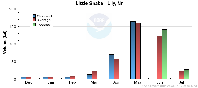
Lily, Nr April-July345405111480
June-July109170115245
White
Meeker, Nr April-July19022076250
June-July7810767140
Watson, Nr April-July19023075270
June-July8411567150


Duchesne Specific Site Forecasts (kaf)

Click site name for graph.
Forecast
Period
90%
Exceedance
Volume
50%
Exceedance
Volume
Percent
Average
10%
Exceedance
Volume
Big Brush Ck
Vernal, Nr, Red Fleet Res, Abv April-July13.2167619.5
June-July4.16.96910.4
Ashley Ck
Vernal, Nr April-July19.4275237
June-July10186428
Wf Duchesne
Hanna, Nr April-July8.412.45218
June-July4.98.87313.2
Duchesne
Tabiona, Nr April-July42605784
June-July22406664
Rock Ck
Upper Stillwater Res April-July38506164
June-July28407054
Mountain Home, Nr April-July42566372
June-July30447160
Currant Ck
Currant Ck Res April-July4.98.43413.4
June-July2.565111
Strawberry
Soldier Springs, Nr April-July21254232
June-July0.524.12511.1
Duchesne, Nr April-July38494066
June-July4.2153232
Duchesne
Duchesne, Nr, Knight Div, Abv April-July7810757144
June-July447362110
Lake Fork
Moon Lake Res, Mtn Home, Nr April-July29395751
June-July20306442
Yellowstone
Altonah, Nr April-July29396350
June-July20306741
Whiterocks
Whiterocks, Nr April-July25356347
June-July15.5256637
Uinta
Neola, Nr April-July29496269
June-July19.6407060
Duchesne
Myton April-July488632150
June-July14.15336117
Randlett, Nr April-July5310633195
June-July16.26936158


Lower Green Specific Site Forecasts (kaf)

Click site name for graph.
Forecast
Period
90%
Exceedance
Volume
50%
Exceedance
Volume
Percent
Average
10%
Exceedance
Volume
White
Blo Tabbyune Ck, Soldier Summit, Nr April-July5.66.7398.3
June-July1.12.2523.8
Fish Ck
Scofield, Nr, Reservoir, Abv April-July13.619.56125
June-July2.25.54811.4
Price
Scofield Res, Scofield, Nr April-July21255431
June-July485314
Green
Green River, Ut April-July17002050652450
June-July7851130661530
Huntington Ck
Electric Lake April-July3.85.1326.8
June-July1.42.7474.4
Huntington, Nr April-July18.1234728
June-July8.6134818.3
Seeley Ck
Joes Vly Res, Orangeville, Nr April-July18.2274738
June-July816.34528
Ferron Ck
Ferron, Nr April-July17.8225627
June-July10.5156520
Muddy Ck
Emery, Nr April-July8.411.65815.7
June-July58.26912.3
Seven Mile Ck
Fish Lake, Nr April-July3.86868.2
June-July0.622.8905
Pine Ck
Escalante, Nr April-July11.4571.9
June-July0.260.62661.1

Differences between the full period forecasts and the residual forecasts may not exactly equal the actual observed volumes due to rounding conventions (see Definitions section).

Reservoir Monthly Inflow Forecasts


Green End of Month Reservoir Contents (kaf)

Usable
Capacity
EOM
Contents
Percent
Usable
Capacity
Last Year
EOM
Last Year
%Capacity
untitled Green
Fontenelle Res, Fontenelle Nr 344.8 116.8 34 231.0 67
Flaming Gorge Res, Flaming Gorge Dam, At 3749.0 3196.2 85 2991.3 80
untitled Strawberry
Strawberry Res 1105.9 995.8 90 1014.0 92
Starvation Res, Duchesne, Nr 165.3 157.8 95 168.6 102
untitled Price
Scofield Res, Scofield, Nr 65.8 39.9 61 52.1 79
untitled Seeley Ck
Joes Vly Res, Orangeville, Nr 61.6 44.7 73 56.0 91
untitled Huntington North Reservoir Storage
4.2 3.5 83 4.0 95
untitled
TOTAL 5496.6 4554.6 83 4517.0 82

Monthly Streamflows


Precipitation Maps


Definitions

10% exceedance forecast: Given the current hydrometeorological conditions, i.e current snowpack, soil moisture and streamflow, the volume that has a 10% chance of being exceeded. Previously referred to as "Reasonable Maximum Forecast".

50% exceedance forecast: Given the current hydrometeorological conditions, i.e current snowpack, soil moisture and streamflow, the volume that has a 50% chance of being exceeded. Previously referred to as "Most Probable Forecast".

90% exceedance forecast: Given the current hydrometeorological conditions, i.e current snowpack, soil moisture and streamflow, the volume that has a 90% chance of being exceeded. Previously referred to as "Reasonable Minimum Forecast".

Acre-Foot (af): The volume equal to one acre covered one foot deep (43,560 cubic feet). See kaf below.

Average: The arithmetic mean. The sum of the values divided by the number of values. Values from 1971-2000 are used for this publication.

Categories: Much Above Average=Greater than 130%, Above Average=111-130%, Near Average=90-110%, Below Average=70-89%, Much Below Average=Less than 70%.

CBRFC: Colorado Basin River Forecast Center.

Forecast Period: The period from April 1 through July 31, unless otherwise noted.

kaf: Thousand Acre-Feet. See Acre-Foot above.

Inflow: The volume of water that flows into a reservoir or lake.

Median: The middle value of an ordered set of values. Half of the values are higher and half of the values are lower. When the set contains an even number of values the median is the average of the two middle numbers.

NOAA: National Oceanic and Atomospheric Administration.

NWS: National Weather Service.

Rounding Conventions:
RangeRound to
0-1.990.01
2.0-19.90.1
20-1991.0
200-9995.0
1000+3 significant digits


Streamflow: The volume of water that flows past a specific stream site.

Water Year: The 12-month period, October 1 through September 30. The water year is designated by the calendar year in which it ends. Thus, the year ending September 30, 2008, is called the "2008 water year."


Additional Information

Water supply forecasts take into consideration present hydrometeorological conditions and use average basin temperatures and precipitation for the forecast period. As the forecast season progresses, a greater portion of the future hydrologic and climatic uncertainty becomes known and monthly forecasts become more accurate. For more information on the tools we use, consult Water Supply Forecasting Tools.

Volume forecasts represent adjusted flows; that is, observed flows with upstream water use taken into account. Adjusted flows will closely approximate natural or unimpaired flows. However, not all upstream diversions or impoundments are measured or quantifiable. For specific adjustments used with each forecast point, consult the Guide to Water Supply Forecasting.

The Water Supply Outlook is issued monthly January through May by the Colorado Basin River Forecast Center. It represents a coordinated effort between the National Weather Service, Natural Resources Conservation Service, Bureau of Reclamation, U.S. Geological Survey and local water district managers.

Note: Data used in this report are provisional and are subject to revision.

For more information, or to be included on the mailing list, please contact:

Colorado Basin River Forecast Center
2242 W North Temple
Salt Lake City, UT 84116
(801) 524-5130
www.cbrfc.noaa.gov


Hydrologist: William Reed