Note: This publication is currently undergoing major revisions. The current publication will be replaced with a new publication based on stakeholder requirements and scientific advances. We expect to begin sharing details on this soon. If you have input on content, format, or publication frequency at any time, please contact us at cbrfc.webmasters@noaa.gov.Great Basin Water Supply Outlook, June 1, 2010

Great Basin Water Supply Outlook, June 1, 2010


Prepared by B.Bernard
NOAA, National Weather Service
Colorado Basin River Forecast Center
Salt Lake City, Utah
www.cbrfc.noaa.gov

Contents

Great Basin Summary


*Median of forecasts within each basin.


Bear Basin Conditions

The following conditions influenced this month's forecasts:

Precipitation:
Seasonal October through May precipitation was near 86 percent of average in the upper Bear Basin. May precipitation was 145 percent of average.

Streamflow:
The Bear River inflow to Woodruff Narrows Reservoir was recorded 51 percent of average streamflow. The Logan River above State Dam recorded 45 percent of average streamflow.

Snowpack:
This year's snow peaked at approximately 70 percent of the average maximum. A brief period of warm temperatures from mid April until April 26th created a good melt before a late season winter storm dropped more snow and again delayed the melt until mid May. As of June 3 the only significant snow remaining is on north slopes above 9100 feet.


Upper Bear River Basin Snow Plot.
Bear River Below Woodruff Narrows Reservoir Snow Plot.
Bear River Basin Snow Plot.

Soil Moisture:
Modeled Soil Moisture, click on map to zoom.

Climate Forecasts:
Climate forecasts were not a factored into the northern Utah forecasts because there is not a strong correlation between El Nino conditions and winter precipitation.

Forecast Summary:
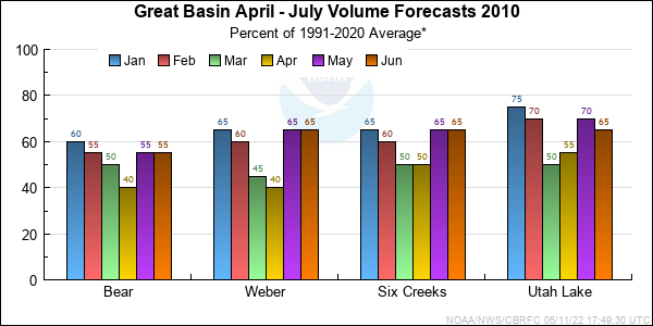
Another Wet and cool month held water supply forecasts steady with no change in the April through July median. April through July seasonal volume forecasts range between 25 and 79 percent of average with a median forecast volume of 56 percent of average. The residual forecast volumes for June through July range from 37 to 93 percent of average with a median forecast volume of 61 percent of average.


* Percent usable capacity, not percent average contents.
Click for multi-month Graph.

Weber Basin Conditions

The following conditions influenced this month's forecasts:

Precipitation:
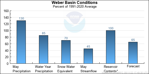
Seasonal October through May precipitation was 84 percent of average in the Weber Basin. May precipitation was 132 percent of average.

Streamflow:
The Weber at Oakley recorded 47 percent of average streamflow due to cool weather and little snowmelt making it to the channel.

Snowpack:
This year's snow pack peak accumulation occurred during mid April at approximately 80 percent of average. The melt was delayed by a series of late spring storms that by mid April caused the snow plots to merge with average on the declining limb of the snow plots. Currently the only significant snow left in the Weber Basin is above 9500 feet and should melt rapidly during the next 10 days or less.

Weber River Basin Snow Plot.
Upper Weber River Basin Snow Plot.

Soil Moisture:
Modeled Soil Moisture, click on map to zoom.

Climate Forecasts:
Climate forecasts were not a factored into the northern Utah forecasts because there is not a strong correlation between El Nino conditions and winter precipitation.

Forecast Summary:
Wet and cool conditions persisted thoughout the Weber basin in May, however there was no change this month to the median April though July forecast volume. April through July seasonal volume forecasts range between 24 and 97 percent of average with a median forecast volume of 65 percent of average. The residual forecast volumes for June through July range from 50 to 100 percent of average with a median forecast volume of 65 percent of average.


* Percent usable capacity, not percent average contents.
Click for multi-month Graph.

Six Creeks Basin Conditions

The following conditions influenced this month's forecasts:

Precipitation:
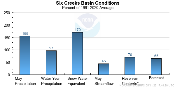
Seasonal October through May precipitation was near 97 percent of average. May precipitation was 155 percent of average.

Streamflow:
Big Cottonwood Creek recorded 44 percent of average streamflow due to unseasonably cool temperatures.

Snowpack:
This year's seasonal peak snow occurred during mid April at approximately 90 percent of average before the first melt began. Then at the end of April a large late season winter storm dropped 7 feet of snow in 4 days in the upper Cottonwood Canyons and delayed the melt until Late May. Currently the only significant snow remaining is above 9000 feet is in the American Fork and the Cottonwood Canyons drainages.

Six Creeks River Basin Snow Plot.

Big and Little Cottonwood Canyons Snow Plot.

Soil Moisture:
Modeled Soil Moisture, click on map to zoom.

Climate Forecasts:
Climate forecasts were not factored into the northern Utah forecasts because there is not a strong correlation between El Nino conditions and winter precipitation.

Forecast Summary:
Another cool and wet month in April delayed the snow melt runoff however the April through July median forecast volumes remains unchanged from last month. April through July seasonal volume forecasts range between 44 and 84 percent of average with a median forecast of 65 percent of average. The residual forecast volumes for June through July range from 56 to 102 percent of average with a median forecast volume of 82 percent of average.


* Percent usable capacity, not percent average contents.
Click for multi-month Graph.

Utah Lake Basin Conditions

The following conditions influenced this month's forecasts:

Precipitation:
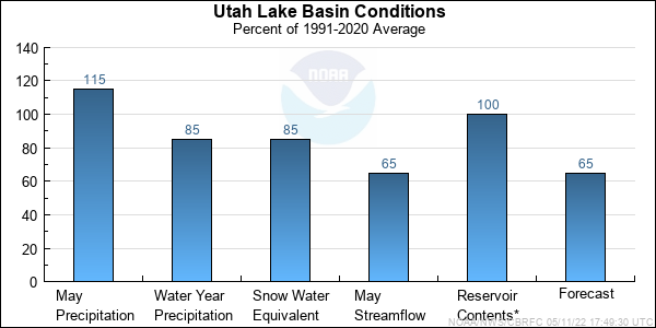
Seasonal October thought May seasonal precipitation was 83 percent of average. May precipitation was 114 percent of average.

Streamflow:
Streamflow conditions for the Provo at Woodland was recorded at 49 percent of average. Inflow to Utah Lake was recorded at 63 percent of average.

Snowpack:
This year's seasonal peak snow occurred approximately May 10th at 80 percent of average for the Utah Lake drainage as a whole. Cool weather during late April delayed the melt some what, however as of June 3rd the only significant snow remaining is above 9100 feet in the headwaters of the Provo and American Fork drainages.

Provo River, Utah Lake Basin Snow Plot.

Soil Moisture:
Modeled Soil Moisture, click on map to zoom.

Climate Forecasts:
Climate forecasts were not factored into the northern Utah forecasts because there is not a strong correlation between El Nino conditions and winter precipitation here.

Forecast Summary:
Despite the cool and wet weather during May there was little change in the median April through July forecast median volume. April through July seasonal volume forecasts range between 53 and 72 percent of average with a median forecast volume of 67 percent of average. The residual forecast volumes for June through July range from 50 to 87 percent of average with a median forecast volume of 77 percent of average.


* Percent usable capacity, not percent average contents.
Click for multi-month Graph.


Bear Specific Site Forecasts (kaf)

Click site name for graph.
Forecast
Period
90%
Exceedance
Volume
50%
Exceedance
Volume
Percent
Average
10%
Exceedance
Volume
Bear
UtahApril-July778979101
June-July53659377
Woodruff Narrows Res *April-July869973112
June-July42555168
Montpelier, Nr, Stewart Dam, Blo *April-July44592575
June-July27413758
Big Ck
Randolph, Nr April-July0.92.2465.8
June-July0.451.4653
Smiths Fork
Border, Nr April-July47575567
June-July28386248
Logan
Logan, Nr, State Dam, Abv April-July63705677
June-July36436150
Blacksmith Fork
Hyrum, Nr, Upnl Dam, Abv April-July22245026
June-July10126014
Little Bear
Paradise April-July22255428
June-July57.55511

*Regulated Forecast, i.e. Observed flow uncorrected for upstream diversion.

Weber Specific Site Forecasts (kaf)

Click site name for graph.
Forecast
Period
90%
Exceedance
Volume
50%
Exceedance
Volume
Percent
Average
10%
Exceedance
Volume
Weber
Oakley, Nr April-July84887298
June-July55618669
Rockport Res, Wanship, Nr April-July718765103
June-July45618577
Coalville, Nr April-July758964103
June-July44588372
Chalk Ck
Coalville April-July28357841
June-July10179923
Weber
Echo Res, Echo, At April-July10011665140
June-July49657890
Lost Ck
Lost Ck Res, Croydon, Nr April-July3.24.2245.2
June-July1.82.8613.8
East Canyon Ck
Jeremy Ranch, Nr April-July12.613.89715.1
June-July2.33.5804.8
East Canyon Res, Morgan, Nr April-July20237426
June-July4.47.47910.4
Weber
Gateway April-July18021561240
June-July609575120
Sf Ogden
Huntsville, Nr April-July25304735
June-July4.59.55914.5
Ogden
Pineview Res, Ogden, Nr April-July49594469
June-July5155025
Wheeler Ck
Huntsville, Nr April-July0.463.4546.5
June-July0.061.1512.9
Centerville Ck
Centerville,nr, Div,abv April-July0.821.3751.8
June-July0.10.6941.1


Six Creeks Specific Site Forecasts (kaf)

Click site name for graph.
Forecast
Period
90%
Exceedance
Volume
50%
Exceedance
Volume
Percent
Average
10%
Exceedance
Volume
Little Cottonwood Ck
Salt Lake City, Nr April-July29328035
June-July22259628
Big Cottonwood Ck
Salt Lake City, Nr April-July20256630
June-July11167621
Mill Ck
Salt Lake City, Nr April-July2.14574.8
June-July2.12.6723.4
Dell Fk
Little Dell Res April-July2.63.3493.7
June-July1.21.6952.3
Parleys Ck
Salt Lake City, Nr April-July8.89.65710.8
June-July3.34.1715.3
Emigration Ck
Salt Lake City, Nr April-July1.72.1472.5
June-July0.30.7561.1
City Ck
Salt Lake City, Nr April-July4.75.6646.5
June-July2.33.2764.1
Vernon Ck
Vernon, Nr April-June0.61682
June-July0.250.581020.91
S Willow Ck
Grantsville, Nr April-July1.93.21004.4
June-July1.31.91052.5
Dunn Ck
Park Valley, Nr April-July0.71.8574.2
June-July0.031.1663.5


Utah Lake Specific Site Forecasts (kaf)

Click site name for graph.
Forecast
Period
90%
Exceedance
Volume
50%
Exceedance
Volume
Percent
Average
10%
Exceedance
Volume
Spanish Fork
Castilla, Nr April-July38415344
June-July17207723
Provo
Woodland, Nr April-July62727082
June-July35458755
Hailstone, Nr April-July68797290
June-July30417752
Deer Ck Res April-July768870100
June-July26386850
American Fork
American Fork, Nr, Up Pwrplnt, AbvApril-July18216624
June-July13168019
West Canyon Ck
Cedar Fort, Nr April-July0.91.3571.7
June-July0.61921.4
Salt Ck
Nephi April-July47.7589.7
June-July0.924736
Jordan
Utah Lake, Provo, Nr April-July20524073270
June-July669880130

Differences between the full period forecasts and the residual forecasts may not exactly equal the actual observed volumes due to rounding conventions (see Definitions section).

Great Basin End of Month Reservoir Contents (kaf)

Usable
Capacity
EOM
Contents
Percent
Usable
Capacity
Last Year
EOM
Last Year
%Capacity
untitled Bear
Woodruff Narrows Res 55.8 0.0 0 57.3 103
untitled Bear River
Bear Lake, Nr Lifton 1302.0 0.0 0 400.9 31
untitled Little Bear
Hyrum Res Abv 15.3 0.0 0 15.5 101
untitled Willard Reservoir Storage
215.0 0.0 0 200.2 93
untitled Sf Ogden
Causey Res 7.1 7.2 101 7.2 101
untitled Ogden
Pineview Res, Ogden, Nr 110.1 110.4 100 110.7 101
untitled Lost Ck
Lost Ck Res, Croydon, Nr 22.5 20.7 92 22.6 100
untitled Weber
Rockport Res, Wanship, Nr 60.9 60.6 100 60.9 100
Echo Res, Echo, At 73.9 73.2 99 74.6 101
untitled East Canyon Ck
East Canyon Res, Morgan, Nr 49.5 50.0 101 49.8 101
untitled Dell Fk
Little Dell Res 20.5 17.3 85 17.3 85
untitled Mountain Dell Dam
3.0 2.0 68 1.6 54
untitled Jordanelle Dam
311.0 251.8 81 311.6 100
untitled Provo
Deer Ck Res 149.7 140.9 94 147.9 99
untitled Jordan
Utah Lake, Provo, Nr 870.9 690.9 79 918.1 105
untitled
TOTAL 3267.2 1425.0 44 2396.3 73

Precipitation Maps


Definitions

10% exceedance forecast: Given the current hydrometeorological conditions, i.e current snowpack, soil moisture and streamflow, the volume that has a 10% chance of being exceeded. Previously referred to as "Reasonable Maximum Forecast".

50% exceedance forecast: Given the current hydrometeorological conditions, i.e current snowpack, soil moisture and streamflow, the volume that has a 50% chance of being exceeded. Previously referred to as "Most Probable Forecast".

90% exceedance forecast: Given the current hydrometeorological conditions, i.e current snowpack, soil moisture and streamflow, the volume that has a 90% chance of being exceeded. Previously referred to as "Reasonable Minimum Forecast".

Acre-Foot (af): The volume equal to one acre covered one foot deep (43,560 cubic feet). See kaf below.

Average: The arithmetic mean. The sum of the values divided by the number of values. Values from 1971-2000 are used for this publication.

Categories: Much Above Average=Greater than 130%, Above Average=111-130%, Near Average=90-110%, Below Average=70-89%, Much Below Average=Less than 70%.

CBRFC: Colorado Basin River Forecast Center.

Forecast Period: The period from April 1 through July 31, unless otherwise noted.

kaf: Thousand Acre-Feet. See Acre-Foot above.

Inflow: The volume of water that flows into a reservoir or lake.

Median: The middle value of an ordered set of values. Half of the values are higher and half of the values are lower. When the set contains an even number of values the median is the average of the two middle numbers.

NOAA: National Oceanic and Atomospheric Administration.

NWS: National Weather Service.

Rounding Conventions:
RangeRound to
0-1.990.01
2.0-19.90.1
20-1991.0
200-9995.0
1000+3 significant digits


Streamflow: The volume of water that flows past a specific stream site.

Water Year: The 12-month period, October 1 through September 30. The water year is designated by the calendar year in which it ends. Thus, the year ending September 30, 2008, is called the "2008 water year."


Additional Information

Water supply forecasts take into consideration present hydrometeorological conditions and use average basin temperatures and precipitation for the forecast period. As the forecast season progresses, a greater portion of the future hydrologic and climatic uncertainty becomes known and monthly forecasts become more accurate. For more information on the tools we use, consult Water Supply Forecasting Tools.

Volume forecasts represent adjusted flows; that is, observed flows with upstream water use taken into account. Adjusted flows will closely approximate natural or unimpaired flows. However, not all upstream diversions or impoundments are measured or quantifiable. For specific adjustments used with each forecast point, consult the Guide to Water Supply Forecasting.

The Water Supply Outlook is issued monthly January through May by the Colorado Basin River Forecast Center. It represents a coordinated effort between the National Weather Service, Natural Resources Conservation Service, Bureau of Reclamation, U.S. Geological Survey and local water district managers.

Note: Data used in this report are provisional and are subject to revision.

For more information, or to be included on the mailing list, please contact:

Colorado Basin River Forecast Center
2242 W North Temple
Salt Lake City, UT 84116
(801) 524-5130
www.cbrfc.noaa.gov


Hydrologist: B.Bernard