sshGreat Basin Water Supply Outlook, June 1, 2008Great Basin Water Supply Outlook, June 1, 2008
Note: This publication is scheduled for revision. If you have feedback on content, format, or publication frequency, please contact us.
Contents
Great Basin Summary
May provided near normal conditions throughout the Great Basin. Stream flows increased to above average
for the latter half of the month after a cool start in May. Maximum temperatures were 3-5 degrees F below normal and
daily mins were mostly normal. Consequently runoff was highly variable and below average except during a 4 day period from May 18-22,
when temperatures reached the low 90's and runoff peaked, before it snowed again. Monthly precipitation for the Great Basin basin
was 96% of average with seasonal precipitation at 93% of average. The snowpack is nearly gone except on due north slopes and areas
above 9000 feet where pockets of late season snow still exist. SNOTEL stations from these sites report a basin total of 101% of
average.
Short term weather guidance from National Weather Service models shows a low pressure system bringing rain and snow
too the area starting on June 4, which will again cool temperatures to below normal and slow the runoff before it picks up again.
This is a continuation of what we've been experiencing for the last 2 months. Longer range temperature forecast call for above average
probabilities of below normal conditions through the 6 to 10 day period. Most streams in the area, with the exception of the
Big and Little Cottonwood creeks and the American Fork river have already peaked, reducing the threat of flooding. Of course,
a heavy rain even could again raise the threat during the next several weeks. Most streams will now begin a slow decline
toward their summer base flows conditions after a brief rise during the next 2 weeks.
Volumetric forecasts for the Great Basin decreased slightly again this month and now range from 64% at Deer Creek Reservoir
to 128% percent of average for Chalk Creek at Coalville. The average forecast from 32 forecast points was 92% of the 1971-2000 average.
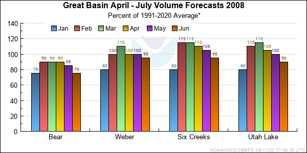
*Median of forecasts within each basin.
Bear Basin Conditions
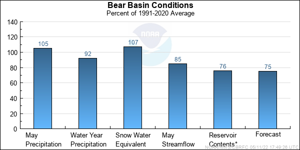
Conditions across the Bear River Basin were normal for the month of May. Snowpack are nearly gone in the Bear but at a few location
still show 107% of average. Snow is currently melting at a rate of 1 to 1.5 inches a day and will be completely gone
within a week or two. Monthly precipitation was 107% of average while seasonal numbers rose slightly to 92% of average.
Streamflows at Bear Utah-Wyoming State Line was 101% of average last month and only 65% of average for the Logan River Near Logan.
Large swings of temperature were responsible for this disparity as the higher elevation regions were colder than average for the
majority of the month. Forecasts in the Bear ranged from 47% at Stewart Dam near Montpelier (observed flow forecast)
to 96% at the Utah-Wyoming State Line.
* Percent usable capacity, not percent average contents.
Click for multi-month Graph.
Weber Basin Conditions
The Weber and Ogden River basins received below average precipitation for the month of May. Monthly precipitation was recorded
at 76% of average and seasonal precipitation dropped to 94% of average. Snow water equivalent numbers are 110% of average,
however 10 of the 16 stations now have no snow and may not really represent what we consider normal conditions. Streamflows
were 98% of average for the Weber at Oakley and 93% of average for Pineview Reservoir. Most snow now lies above 8500 feet and
is diminishing rapidly. The April through July volume forecasts range from 72% of average at Lost Creek Reservoir near Croydon to
143% of average at Wheeler Creek near Huntsville.

* Percent usable capacity, not percent average contents.
Click for multi-month Graph.
Six Creeks Basin Conditions
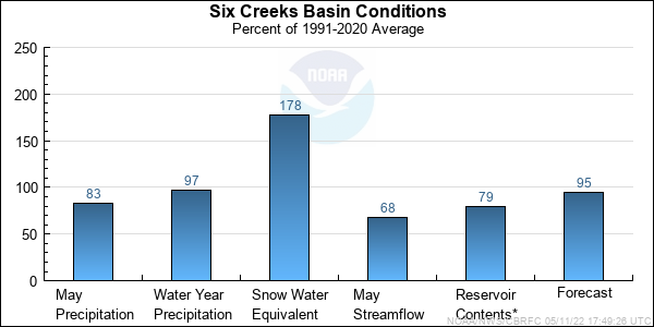
Monthly precipitation over the Six Creeks drainages was below average for May at 85% of average. Seasonal precipitation totals dropped
to 98% of average as a result. Indexed snow numbers for Six Creeks remains much above average at 178%, however the areal extent is
very small now and confined to the uppermost elevations, skewing the meaning of this standard measure. Steamflow in Big Cottonwood Creek near Salt Lake City was 75% of average and never
really reach average flow numbers due to the below average maximum temperatures during the month of May and are likely to rise once
temperatures return to normal, however we do not expect high peaks with the current extent of snow cover. April through July volume
forecasts range from 78% percent of average at Parley's near Salt Lake City to 108% percent of average for Little
Cottonwood Creek near Salt Lake City.
* Percent usable capacity, not percent average contents.
Click for multi-month Graph.
Utah Lake Basin Conditions
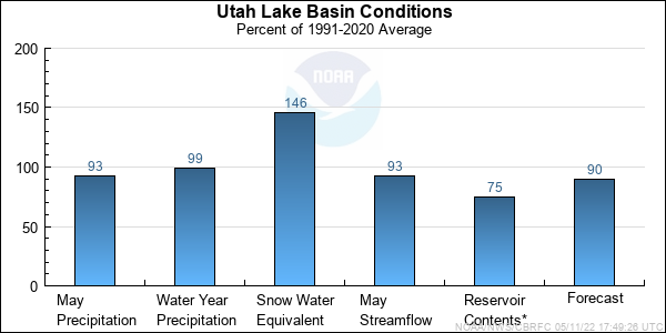
Monthly precipitation for Utah Lake Basin was 99% of average and seasonal precipitation totals 100% of average. Currently the
indexed snow for the Utah Lake Basin is 146% of average. This months SWE values are much the same as last month but because of
the delayed melt, the daily averages appear to be going up which is not the case. This is not really a representation of building
snow but more of how cool our temperatures have been this spring at the upper elevations. Forecasts for Utah Lake ranged from 64%
at Deer Creek Reservoir to 100% for the American Fork near the UP Power Plant, American Fork Canyon.
* Percent usable capacity, not percent average contents.
Click for multi-month Graph.
Differences between the full period forecasts and the residual forecasts may not exactly equal the actual observed volumes due to rounding conventions (see Definitions section).
Precipitation Maps


Hydrologist: Brent Bernard
