Green Water Supply Outlook, February 1, 2008

Note: This publication is scheduled for revision. If you have feedback on content, format, or publication frequency, please contact us.
Prepared by Ed Clark
NOAA, National Weather Service
Colorado Basin River Forecast Center
Salt Lake City, Utah
www.cbrfc.noaa.gov

Contents

Green Summary

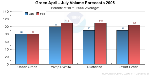
The Green River Basin continues to have a wide distribution of water supply outlook conditions. Storm patterns favored the basin below Flaming Gorge helping to increase the forecast for those areas. Conditions upstream from Flaming Gorge continue to be below average.


*Median of forecasts within each basin.


Upper Green Basin Conditions

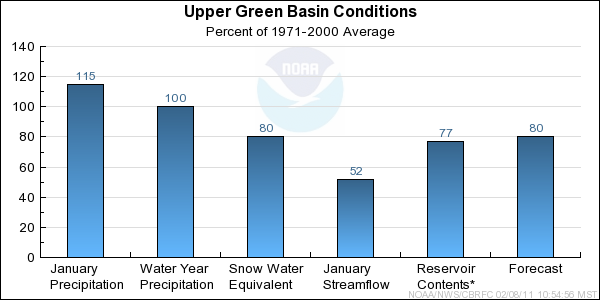
January precipitation was above average at 115%. This brings the seasonal precipitation to near average conditions throughout many basins. However, the snowpack remains below average at 80% basin wide. The below average soil moisture states within the model continue to decrease objective guidance values. While NOAA's Climate Prediction Center indicates the potential for wetter than normal conditions over the next 30 days, shorter term weather models do not indicate significant precipitation in the Upper Green River Basin over the next 10 days. This influenced the decrease in the coordinated forecast for many points. Like December, monthly inflow to Flaming Gorge was near 50% of average.


* Percent usable capacity, not percent average contents.
Click for multi-month Graph.

Yampa/White Basin Conditions

Monthly precipitation for January was 145% of average in the Yampa River basin. Snowpack increased from 85% of basin average on January 1, to 110% on February 1. The Elk and Little Snake drainages show the best conditions with some stations near their seasonal maximum. Due to these improved conditions, forecasts increased throughout the Yampa and White Basins.


* Percent usable capacity, not percent average contents.
Click for multi-month Graph.

Duchesne Basin Conditions

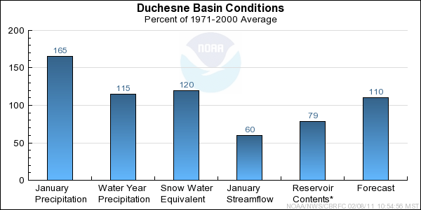
January precipitation was 165 % of average. The snowpack, which had high variability at the end of December, has increase to 120% of average as of February 1. All stations within the Uinta Basin have average to above average conditions. As a result, forecasts increased throughout the basin.


* Percent usable capacity, not percent average contents.
Click for multi-month Graph.

Lower Green Basin Conditions

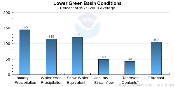
Similar to the Yampa and Duchesne, January precipitation has brought the snow pack from below average to above average conditions in the Lower Green. Basin wide, snow pack is 120% of average as of February 1. As one would expect, forecasts for the Eastern side of the Wasatch Plateau increased to a basin median of 105%.

It's worth noting that monthly precipitation reported by lower elevation gages in the San Rafael Swell region was below average for January. However, this area does not normally contribute substantial snow melt volume to forecast points within the Lower Green Basin.


* Percent usable capacity, not percent average contents.
Click for multi-month Graph.


Upper Green Specific Site Forecasts (kaf)

Click site name for graph.
Forecast
Period
90%
Exceedance
Volume
50%
Exceedance
Volume
Percent
Average
10%
Exceedance
Volume
Green
Daniel, Nr, Warren Bridge, At April-July17422585285
Pine Ck
Fremont Lk, Abv April-July749087107
New Fork
Big Piney, Nr April-July21531580435
Green
Fontenelle Res, Fontenelle Nr April-July40066577995
Big Sandy
Farson, Nr April-July31457863
Green
Green River, Wy, Nr April-July43067077960
Hams Fork
Frontier, Nr, Pole Ck, Blo April-July25456971
Viva Naughton Res April-July31596695
Blacks Fork
Robertson, Nr April-July538084112
Ef Smiths Fork
Robertson, Nr April-July13.8237935
Green
Flaming Gorge Res, Flaming Gorge Dam, At April-July470840711320


Yampa/White Specific Site Forecasts (kaf)

Click site name for graph.
Forecast
Period
90%
Exceedance
Volume
50%
Exceedance
Volume
Percent
Average
10%
Exceedance
Volume
Yampa
Stagecoach Rsvr, Abv April-July203311451
Steamboat Springs April-July20527598360
Elk
Milner, Nr April-July265350108445
Elkhead Ck
Elkhead, Nr April-July284311061
Maynard Gulch, Blo April-July477011998
Fortification Ck
Fortification, Nr March-June4.5810712.9
Yampa
Maybell, Nr April-July71510201031380
Little Snake
Slater, Nr April-July129178112235
Dixon, Nr April-July265385117530
Lily, Nr April-July285430118610
White
Meeker, Nr April-July225315109420
Watson, Nr April-July197335110475


Duchesne Specific Site Forecasts (kaf)

Click site name for graph.
Forecast
Period
90%
Exceedance
Volume
50%
Exceedance
Volume
Percent
Average
10%
Exceedance
Volume
Big Brush Ck
Vernal, Nr, Red Fleet Res, Abv April-July15.22311032
Ashley Ck
Vernal, Nr April-July365610880
Wf Duchesne
Hanna, Nr April-July17.82711338
Duchesne
Tabiona, Nr April-July74110105153
Rock Ck
Upper Stillwater Res April-July6890110115
Mountain Home, Nr April-July7297109126
Currant Ck
Currant Ck Res April-July15.52811244
Strawberry
Soldier Springs, Nr April-July346210598
Duchesne, Nr April-July69125102197
Duchesne
Duchesne, Nr, Knight Div, Abv April-July140200106270
Lake Fork
Moon Lake Res, Mtn Home, Nr April-July557511098
Yellowstone
Altonah, Nr April-July497011394
Whiterocks
Whiterocks, Nr April-July396110987
Duchesne
Myton April-July139290109495
Randlett, Nr April-July164345106595


Lower Green Specific Site Forecasts (kaf)

Click site name for graph.
Forecast
Period
90%
Exceedance
Volume
50%
Exceedance
Volume
Percent
Average
10%
Exceedance
Volume
White
Blo Tabbyune Ck, Soldier Summit, Nr April-July11.51810326
Gooseberry Ck
Scofield, Nr April-July8.41310918.6
Price
Scofield Res, Scofield, Nr April-July335111174
Green
Green River, Ut April-July16203000954380
Huntington Ck
Electric Lake April-July10.31610223
Huntington, Nr April-July325010274
Seeley Ck
Joes Vly Res, Orangeville, Nr April-July375810084
Ferron Ck
Ferron, Nr April-July294311059
Muddy Ck
Emery, Nr April-July14.42311634

Differences between the full period forecasts and the residual forecasts may not exactly equal the actual observed volumes due to rounding conventions (see Definitions section).

Green Reservoir Contents (kaf)

Usable
Capacity
EOM
Contents
Percent
Usable
Capacity
Last Year
EOM
Last Year
%Capacity
untitled Green
Fontenelle Res, Fontenelle Nr 344.8 127.8 37 151.7 44
Flaming Gorge Res, Flaming Gorge Dam, At 3749.0 3020.4 81 3109.2 83
untitled Strawberry
Strawberry Res 1105.9 877.6 79 928.0 84
Starvation Res, Duchesne, Nr 165.3 134.6 81 141.8 86
untitled Price
Scofield Res, Scofield, Nr 65.8 14.6 22 36.5 55
untitled Seeley Ck
Joes Vly Res, Orangeville, Nr 61.6 40.5 66 45.2 73
untitled Huntington North Reservoir Storage
4.2 2.1 49 0.6 15
untitled
TOTAL 5496.6 4217.5 77 4413.0 80

Precipitation Maps


Definitions

10% exceedance forecast: Given the current hydrometeorological conditions, i.e current snowpack, soil moisture and streamflow, the volume that has a 10% chance of being exceeded. Previously referred to as "Reasonable Maximum Forecast".

50% exceedance forecast: Given the current hydrometeorological conditions, i.e current snowpack, soil moisture and streamflow, the volume that has a 50% chance of being exceeded. Previously referred to as "Most Probable Forecast".

90% exceedance forecast: Given the current hydrometeorological conditions, i.e current snowpack, soil moisture and streamflow, the volume that has a 90% chance of being exceeded. Previously referred to as "Reasonable Minimum Forecast".

Acre-Foot (af): The volume equal to one acre covered one foot deep (43,560 cubic feet). See kaf below.

Average: The arithmetic mean. The sum of the values divided by the number of values. Values from 1971-2000 are used for this publication.

Categories: Much Above Average=Greater than 130%, Above Average=111-130%, Near Average=90-110%, Below Average=70-89%, Much Below Average=Less than 70%.

CBRFC: Colorado Basin River Forecast Center.

Forecast Period: The period from April 1 through July 31, unless otherwise noted.

kaf: Thousand Acre-Feet. See Acre-Foot above.

Inflow: The volume of water that flows into a reservoir or lake.

Median: The middle value of an ordered set of values. Half of the values are higher and half of the values are lower. When the set contains an even number of values the median is the average of the two middle numbers.

NOAA: National Oceanic and Atomospheric Administration.

NWS: National Weather Service.

Rounding Conventions:
RangeRound to
0-1.990.01
2.0-19.90.1
20-1991.0
200-9995.0
1000+3 significant digits


Streamflow: The volume of water that flows past a specific stream site.

Water Year: The 12-month period, October 1 through September 30. The water year is designated by the calendar year in which it ends. Thus, the year ending September 30, 2008, is called the "2008 water year."


Additional Information

Water supply forecasts take into consideration present hydrometeorological conditions and use average basin temperatures and precipitation for the forecast period. As the forecast season progresses, a greater portion of the future hydrologic and climatic uncertainty becomes known and monthly forecasts become more accurate. For more information on the tools we use, consult Water Supply Forecasting Tools.

Volume forecasts represent adjusted flows; that is, observed flows with upstream water use taken into account. Adjusted flows will closely approximate natural or unimpaired flows. However, not all upstream diversions or impoundments are measured or quantifiable. For specific adjustments used with each forecast point, consult the Guide to Water Supply Forecasting.

The Water Supply Outlook is issued monthly January through May by the Colorado Basin River Forecast Center. It represents a coordinated effort between the National Weather Service, Natural Resources Conservation Service, Bureau of Reclamation, U.S. Geological Survey and local water district managers.

Note: Data used in this report are provisional and are subject to revision.

For more information, or to be included on the mailing list, please contact:

Colorado Basin River Forecast Center
2242 W North Temple
Salt Lake City, UT 84116
(801) 524-5130
www.cbrfc.noaa.gov


Hydrologist: Ed Clark