Green Water Supply Outlook, May 1, 2008
Note: This publication is scheduled for revision. If you have feedback on content, format, or publication frequency, please contact us.
Contents
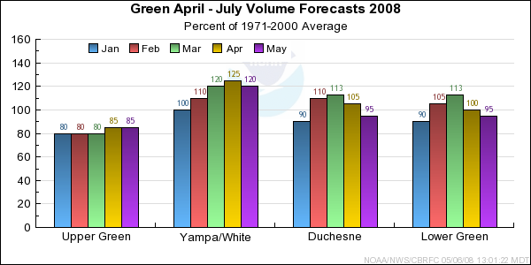
Green Summary
Nearly the entire basin received much below average precipitation
with the Yampa receiving below average precipitation. Similar to March, April
temperatures were below average for all basins within the Green. Both maximum and
minimum daily temperatures were 3 to 5 Fahrenheit degrees below average. While
additional liquid was not added to the snowpack, cooler temperatures help preserve
that which was on the ground. Additionally, many stream flow observations were below
average due to decrease melt during April.
*Median of forecasts within each basin.
Upper Green Basin Conditions
Dry antecedent soil moisture conditions continue to influence a lower volumetric forecast
from the River Forecast Model. While the May 1st snowpack is 95 percent of average, the
basin median forecast is only 80 percent of average.
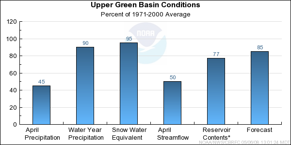
* Percent usable capacity, not percent average contents.
Click for multi-month Graph.
Yampa/White Basin Conditions
Overall the Yampa and White basins received only 80 percent of average April
Precipitation. The Upper Yampa basin received almost 100 percent of its normal precipitation.
This, coupled with cooler temperatures that preserved much of the snowpack led to slightly increased forecasts
on portions of the Little Snake and Yampa.
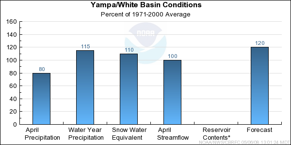
* Percent usable capacity, not percent average contents.
Click for multi-month Graph.
Duchesne Basin Conditions
April precipitation in the Duchesne Basin was only 45 percent of average.
However due to much above average precipitation in February and March, the seasonal
snowpack remains near average. Soil moisture conditions prior to the melt were normal.
Overall forecast dropped slightly to reflect the seasonal precipitation values.
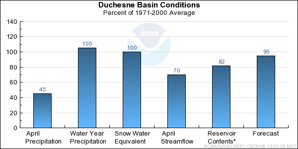
* Percent usable capacity, not percent average contents.
Click for multi-month Graph.
Lower Green Basin Conditions
Similar to the Duchesne, precipitation in April was much below average. Most points are
forecast to see a near normal April through July runoff. Outliers include both Ferron Creek
and inflow to Joes Valley where volumes are expected to be below average.
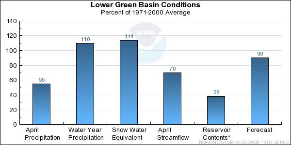
* Percent usable capacity, not percent average contents.
Click for multi-month Graph.
Differences between the full period forecasts and the residual forecasts may not exactly equal the actual observed volumes due to rounding conventions (see Definitions section).
Precipitation Maps


Hydrologist: Ed Clark
