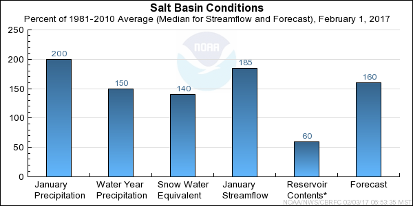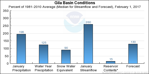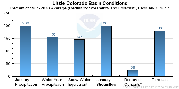
NOAA, National Weather Service
Colorado Basin River Forecast Center
Salt Lake City, Utah
www.cbrfc.noaa.gov
 | Prepared by T. Cox NOAA, National Weather Service Colorado Basin River Forecast Center Salt Lake City, Utah www.cbrfc.noaa.gov |


| Forecast Period | 90% Exceedance Volume | 70% Exceedance Volume | 50% Exceedance Volume | Percent Median | 30% Exceedance Volume | 10% Exceedance Volume | |
| Salt | |||||||
| Roosevelt, Nr | January-May | 315 | 380 | 500 | 161 | 630 | 775 |
| February-May | 150 | 215 | 335 | 118 | 465 | 610 | |
| Tonto Ck | |||||||
| Roosevelt, Nr, Gun Ck, Abv | January-May | 74 | 92 | 119 | 283 | 158 | 220 |
| February-May | 20 | 38 | 65 | 186 | 104 | 168 | |
| Verde | |||||||
| Tangle Ck, Blo, Horseshoe Dam, Abv | January-May | 210 | 260 | 325 | 207 | 490 | 640 |
| February-May | 97 | 150 | 215 | 158 | 380 | 530 |
| Forecast Period | 90% Exceedance Volume | 70% Exceedance Volume | 50% Exceedance Volume | Percent Median | 30% Exceedance Volume | 10% Exceedance Volume | |
| Gila | |||||||
| Gila, Nr | January-May | 70 | 80 | 101 | 180 | 120 | 171 |
| February-May | 34 | 44 | 65 | 130 | 84 | 135 | |
| Virden, Nr, Blue Ck, Blo | January-May | 113 | 125 | 150 | 197 | 179 | 250 |
| February-May | 48 | 60 | 85 | 135 | 114 | 185 | |
| Solomon, Nr, Head Of Safford Vly | January-May | 185 | 210 | 250 | 182 | 310 | 430 |
| February-May | 94 | 120 | 158 | 128 | 220 | 340 | |
| San Carlos Res, Coolidge Dam, At | January-May | 158 | 186 | 220 | 232 | 290 | 415 |
| February-May | 66 | 94 | 127 | 157 | 196 | 325 | |
| San Francisco | |||||||
| Glenwood, Nr | January-May | 15.3 | 17.3 | 21 | 100 | 31 | 42 |
| February-May | 10.9 | 12.9 | 17 | 93 | 27 | 38 | |
| Clifton | January-May | 63 | 76 | 90 | 148 | 121 | 160 |
| February-May | 30 | 43 | 57 | 112 | 88 | 127 |
| Forecast Period | 90% Exceedance Volume | 70% Exceedance Volume | 50% Exceedance Volume | Percent Median | 30% Exceedance Volume | 10% Exceedance Volume | |
| Little Colorado | |||||||
| Lyman Lk, Abv, St. Johns, Nr | January-June | 3.2 | 4.1 | 4.8 | 68 | 6.1 | 7.8 |
| February-June | 2.1 | 3 | 3.7 | 56 | 5 | 6.7 | |
| Zuni | |||||||
| Black Rock Res, Abv | January-May | 0.13 | 0.38 | 0.74 | 157 | 2.6 | 6.5 |
| February-May | 0.1 | 0.35 | 0.71 | 187 | 2.6 | 6.5 | |
| Chevelon Ck | |||||||
| Winslow, Nr, Wildcat Cyn, Blo | January-May | 18.2 | 27 | 34 | 245 | 57 | 72 |
| February-May | 8.7 | 18 | 25 | 180 | 48 | 63 |
| EOM Contents | Percent EOM Average | Percent Usable Capacity | Last Year EOM | Last Year %Average | EOM Average | Usable Capacity | |
| Salt | |||||||
| Roosevelt | 819.6 | 91 | 50 | 753.3 | 84 | 901.4 | 1653.0 |
| Horse Mesa | 230.0 | 104 | 94 | 224.7 | 101 | 222.0 | 245.1 |
| Mormon Flat | 55.5 | 102 | 96 | 54.4 | 100 | 54.5 | 57.9 |
| Stewart Mountain | 68.5 | 110 | 98 | 64.4 | 104 | 62.2 | 69.8 |
| Horseshoe | 91.4 | 243 | 84 | 63.4 | 168 | 37.6 | 109.2 |
| Bartlett | 133.9 | 115 | 75 | 83.7 | 72 | 116.8 | 178.2 |
|
| |||||||
| TOTAL | 1399.0 | 100 | 60 | 1243.9 | 89 | 1394.6 | 2313.2 |
| Bill Williams | |||||||
| Alamo | 79.0 | 55 | 8 | 53.4 | 37 | 143.3 | 1045.0 |
| Agua Fria | |||||||
| Lake Pleasant | 728.0 | 113 | 84 | 751.0 | 117 | 641.6 | 869.9 |
| Gila | |||||||
| San Carlos | 139.6 | 38 | 16 | 97.2 | 26 | 366.8 | 875.0 |
| Colorado | |||||||
| Lake Powell | 11359.3 | 66 | 47 | 11426.7 | 66 | 17338.2 | 24322.0 |
| Lake Mead | 10509.3 | 51 | 40 | 10318.0 | 50 | 20452.4 | 26120.0 |
|
| |||||||
| TOTAL | 22815.2 | 59 | 43 | 22646.2 | 58 | 38942.2 | 53231.9 |
| Range | Round to | |
| 0-1.99 | 0.01 | |
| 2.0-19.9 | 0.1 | |
| 20-199 | 1.0 | |
| 200-999 | 5.0 | |
| 1000+ | 3 significant digits |