Great Basin Water Supply Outlook, April 1, 2019

Note: This publication is scheduled for revision. If you have feedback on content, format, or publication frequency, please contact us.
Prepared by Brent.Bernard, Patrick Kormos
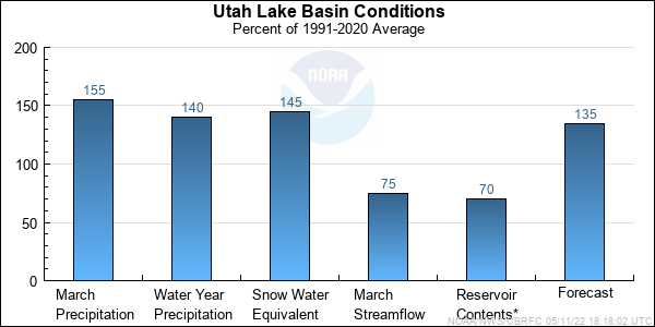
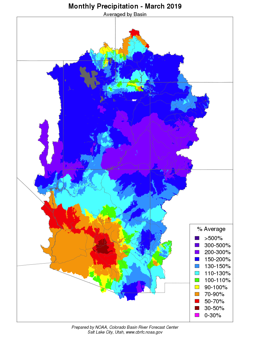
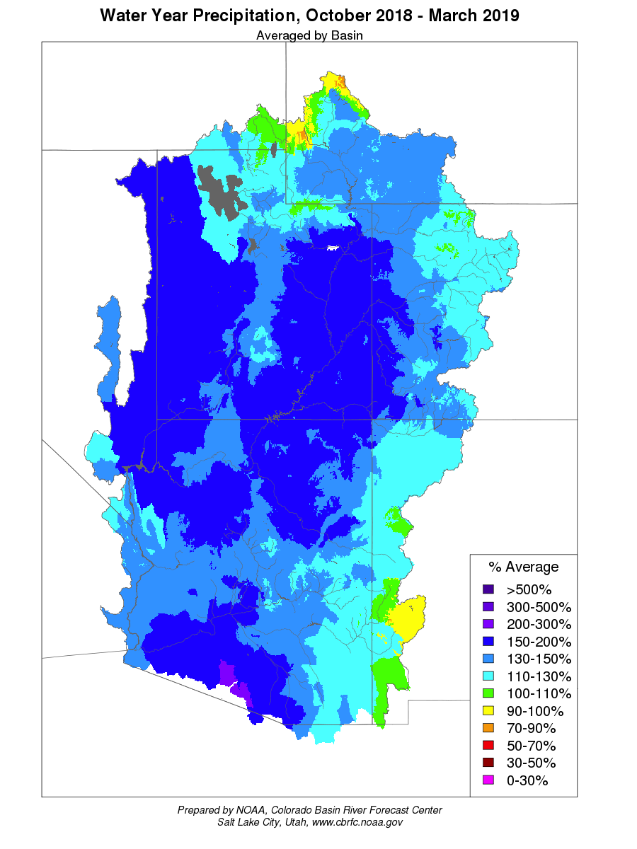
NOAA, National Weather Service
Colorado Basin River Forecast Center
Salt Lake City, Utah
www.cbrfc.noaa.gov

Contents

Great Basin Summary


*Median of forecasts within each basin.


Bear Basin Conditions


Snow Water Equivalent in Percent of Median.
* Percent usable capacity, not percent average contents.
Click for multi-month Graph.

Weber Basin Conditions


Snow Water Equivalent in Percent of Median.
* Percent usable capacity, not percent average contents.
Click for multi-month Graph.

Six Creeks Basin Conditions


Snow Water Equivalent in Percent of Median.
* Percent usable capacity, not percent average contents.
Click for multi-month Graph.

Utah Lake Basin Conditions


Snow Water Equivalent in Percent of Median.
* Percent usable capacity, not percent average contents.
Click for multi-month Graph.


Bear Specific Site Forecasts (kaf)

Click site name for graph.
Forecast
Period
90%
Exceedance
Volume
70%
Exceedance
Volume
50%
Exceedance
Volume
Percent
Average
30%
Exceedance
Volume
10%
Exceedance
Volume
Bear
Utah April-July106 115 124 111 131 148
Woodruff Narrows Rsvr, Abv April-July95 108 121 100 126 157
Montpelier, Nr, Stewart Dam, Blo * April-July104 125 146 80 170 230
Smiths Fork
Border, Nr April-July61 67 76 85 81 90
Logan
Logan, Nr, State Dam, Abv April-July90 96 104 94 115 127
Blacksmith Fork
Hyrum, Nr, Upnl Dam, Abv April-July53 59 61 142 67 79
Little Bear
Paradise April-July44 50 55 117 69 75

*Regulated Forecast, i.e. Observed flow uncorrected for upstream diversion.

Weber Specific Site Forecasts (kaf)

Click site name for graph.
Forecast
Period
90%
Exceedance
Volume
70%
Exceedance
Volume
50%
Exceedance
Volume
Percent
Average
30%
Exceedance
Volume
10%
Exceedance
Volume
Weber
Oakley, Nr April-July104 112 130 110 134 153
Rockport Res, Wanship, Nr April-July120 131 140 106 158 187
Coalville, Nr April-July125 137 147 110 165 197
Chalk Ck
Coalville April-July41 45 48 117 59 78
Weber
Echo Res, Echo, At April-July167 184 193 113 225 275
Lost Ck
Lost Ck Res, Croydon, Nr April-July13.8 15 16 119 17.8 23
East Canyon Ck
East Canyon Res, Morgan, Nr April-July31 35 39 144 41 50
Weber
Gateway April-July350 370 390 120 500 570
Sf Ogden
Huntsville, Nr April-July75 79 86 154 97 116
Ogden
Pineview Res, Ogden, Nr April-July153 173 184 163 210 240


Six Creeks Specific Site Forecasts (kaf)

Click site name for graph.
Forecast
Period
90%
Exceedance
Volume
70%
Exceedance
Volume
50%
Exceedance
Volume
Percent
Average
30%
Exceedance
Volume
10%
Exceedance
Volume
Little Cottonwood Ck
Salt Lake City, Nr April-July43 46 47 124 52 56
Big Cottonwood Ck
Salt Lake City, Nr April-July39 42 44 122 48 54
Mill Ck
Salt Lake City, Nr April-July5.5 6.2 6.4 100 7.1 8.3
Dell Fk
Little Dell Res April-July5.9 6.6 6.8 124 8 9.7
Lambs Ck
Salt Lake City, Nr April-July5.4 6.4 6.7 126 7.6 9.2
Parleys Ck
Salt Lake City, Nr April-July15.5 17.9 18.3 129 21 26
Emigration Ck
Salt Lake City, Nr April-July4 4.8 5.2 130 6 7
Red Butte Ck
Ft Douglas, At, Salt Lake City, Nr April-July1.7 2 2 104 2.4 2.8
City Ck
Salt Lake City, Nr April-July7.3 7.9 8.3 108 9.5 10.4
S Willow Ck
Grantsville, Nr April-July2.5 2.8 3.1 100 3.6 4.1


Utah Lake Specific Site Forecasts (kaf)

Click site name for graph.
Forecast
Period
90%
Exceedance
Volume
70%
Exceedance
Volume
50%
Exceedance
Volume
Percent
Average
30%
Exceedance
Volume
10%
Exceedance
Volume
Spanish Fork
Castilla, Nr April-July91 105 109 158 122 139
Provo
Woodland, Nr April-July103 113 122 122 130 149
Hailstone, Nr April-July118 130 134 122 146 169
Deer Ck Res April-July156 174 182 143 198 225
American Fork
American Fork, Nr, Up Pwrplnt, Abv April-July37 40 42 135 46 51
West Canyon Ck
Cedar Fort, Nr April-July1.4 2.1 2.2 125 2.7 4.2
Salt Ck
Nephi Powerplant Div, Blo April-July17 23 25 301 28 30
Jordan
Utah Lake, Provo, Nr April-July400 445 450 138 510 560

Differences between the full period forecasts and the residual forecasts may not exactly equal the actual observed volumes due to rounding conventions (see Definitions section).

Great Basin End of Month Reservoir Contents (kaf)

EOM
Contents
Percent
EOM
Average
Percent
Usable
Capacity
Last Year
EOM
Last Year
%Average
EOM
Average
Usable
Capacity
untitled Bear
Woodruff Narrows Res, Woodruff, Nr 25.2 66 45 57.8 151 38.2 55.8
untitled Bear River
Bear Lake, Nr Lifton 970.0 133 75 1121.7 153 731.1 1302.0
untitled Little Bear
Hyrum Reservoir 10.2 79 67 11.8 90 13.0 15.3
untitled Weber
Rockport Res, Wanship, Nr 36.4 97 66 54.8 146 37.6 55.2
Echo Res, Echo, At 31.9 64 43 65.8 131 50.2 73.9
untitled Lost Ck
Lost Ck Res, Croydon, Nr 15.3 137 68 19.6 176 11.2 22.5
untitled East Canyon Ck
East Canyon Res, Morgan, Nr 33.1 93 67 44.4 125 35.5 49.5
untitled Sf Ogden
Causey Res 3.3 102 46 6.8 211 3.2 7.1
untitled Ogden
Pineview Res, Ogden, Nr 70.3 112 64 86.5 138 62.7 110.1
untitled Jordanelle Dam
193.9 80 61 256.5 106 242.0 320.3
untitled Provo
Deer Ck Res 131.6 110 88 149.6 125 119.4 149.7
untitled Dell Fk
Little Dell Res 14.2 -99 69 15.4 -99 -9999.0 20.5
untitled Jordan
Utah Lake, Provo, Nr 579.0 71 66 637.5 78 812.8 870.9
untitled
TOTAL 2100.3 97 69 2512.6 116 2157.1 3052.8

Precipitation Maps


Definitions

10% exceedance forecast: Given the current hydrometeorological conditions, i.e current snowpack, soil moisture and streamflow, the volume that has a 10% chance of being exceeded. Previously referred to as "Reasonable Maximum Forecast".

50% exceedance forecast: Given the current hydrometeorological conditions, i.e current snowpack, soil moisture and streamflow, the volume that has a 50% chance of being exceeded. Previously referred to as "Most Probable Forecast".

90% exceedance forecast: Given the current hydrometeorological conditions, i.e current snowpack, soil moisture and streamflow, the volume that has a 90% chance of being exceeded. Previously referred to as "Reasonable Minimum Forecast".

Acre-Foot (af): The volume equal to one acre covered one foot deep (43,560 cubic feet). See kaf below.

Average: The arithmetic mean. The sum of the values divided by the number of values. Values from 1981-2010 are used for this publication.

Categories: Much Above Average=Greater than 130%, Above Average=111-130%, Near Average=90-110%, Below Average=70-89%, Much Below Average=Less than 70%.

CBRFC: Colorado Basin River Forecast Center.

Forecast Period: The period from April 1 through July 31, unless otherwise noted.

kaf: Thousand Acre-Feet. See Acre-Foot above.

Inflow: The volume of water that flows into a reservoir or lake.

Median: The middle value of an ordered set of values. Half of the values are higher and half of the values are lower. When the set contains an even number of values the median is the average of the two middle numbers.

NOAA: National Oceanic and Atomospheric Administration.

NWS: National Weather Service.

Rounding Conventions:
RangeRound to
0-1.990.01
2.0-19.90.1
20-1991.0
200-9995.0
1000+3 significant digits


Streamflow: The volume of water that flows past a specific stream site.

Water Year: The 12-month period, October 1 through September 30. The water year is designated by the calendar year in which it ends. Thus, the year ending September 30, 2008, is called the "2008 water year."


Additional Information

Water supply forecasts take into consideration present hydrometeorological conditions and use average basin temperatures and precipitation for the forecast period. As the forecast season progresses, a greater portion of the future hydrologic and climatic uncertainty becomes known and monthly forecasts become more accurate. For more information on the tools we use, consult Water Supply Forecasting Tools.

Volume forecasts represent adjusted flows; that is, observed flows with upstream water use taken into account. Adjusted flows will closely approximate natural or unimpaired flows. However, not all upstream diversions or impoundments are measured or quantifiable. For specific adjustments used with each forecast point, consult the Guide to Water Supply Forecasting.

The Water Supply Outlook is issued monthly January through May by the Colorado Basin River Forecast Center. It represents a coordinated effort between the National Weather Service, Natural Resources Conservation Service, Bureau of Reclamation, U.S. Geological Survey and local water district managers.

Note: Data used in this report are provisional and are subject to revision.

For more information, or to be included on the mailing list, please contact:

Colorado Basin River Forecast Center
2242 W North Temple
Salt Lake City, UT 84116
(801) 524-5130
www.cbrfc.noaa.gov


Hydrologist: Brent.Bernard, Patrick Kormos