See the
Story Map About Us for more information.
What is the Colorado Basin River Forecast Center (CBRFC)?
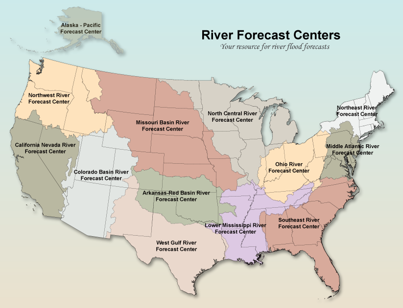
The National Weather Service (NWS) operates 13 hydrologic centers across the country known as River Forecast Centers (RFCs).
The CBRFC is one of these RFCs and is located in Salt Lake City, Utah.
What Do We Do?
As part of the NWS Hydrologic Services Program, we provide flood forecasts and warnings for the protection of lives and property.
We also provide hydrologic forecast information for the national environmental and economic well being.
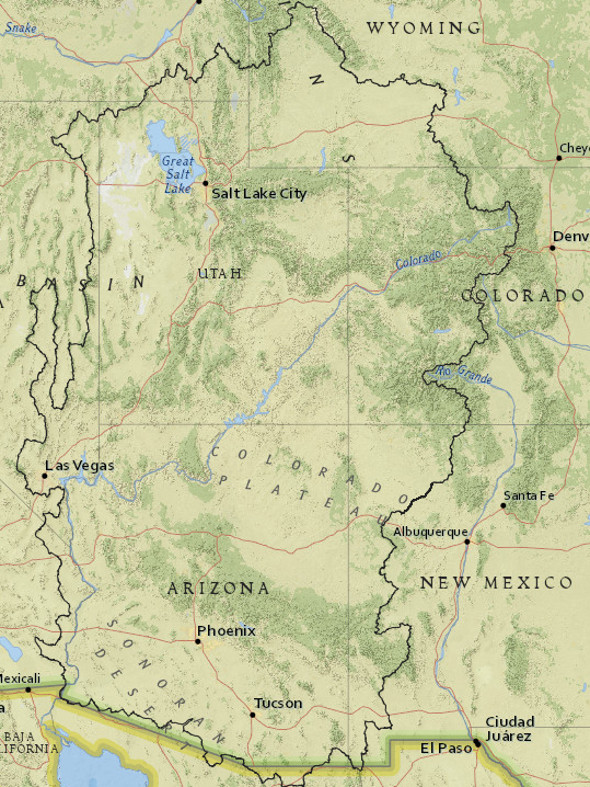
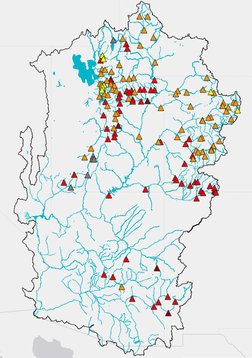
Our area of responsibility is the Colorado and Eastern Great Basins.
This includes all of Utah and Arizona plus areas of the surronding states.
The area ranges in elevation from 200 to over 14000 feet and exhibits extreme variation in hydrologic regimes.
The area is environmentally sensitive with extreme pressure placed on water resources.
We continuously assimilate hydrometeorological data, model river basins, and produce hydrologic forecasts and guidance.
Our stake holders include internal NWS Weather Forecast Offices (WFOs), outside water management agencies, emergency managers, and the public.
We internally research, develop, and implement the methods and technology to facilitate and support our products.
What Do We Forecast
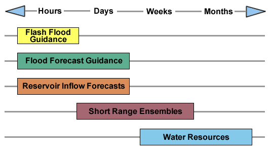
We provide hydrologic guidance for time scales that vary from
hours (flash flood guidance, flood forecasts, and reservoir inflows),
to days (flood forecasts, reservoir inflows),
to weeks (short-range ensembles and peak flows),
to months (water supply).
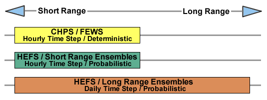
To develop this guidance we employ a host of hydrologic models and methods.
These range from simple to complex and empirical to process simulation.
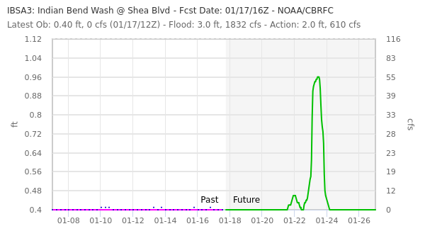
What Forecasts Do We Issue?
Floods are a natural and inevitable occurrence along the rivers of our country.
In our area, winter flooding is caused by heavy precipitation events,
while spring flood events result from snowmelt, augmented by precipitation.
We use the NWS Community Hydrologic Prediction System (CHPS) to simulate soil, snow, stream channel and reservoir conditions.
Daily forecasts are made using observations of temperature and precipitation.
Forecast of meteorological parameters are included in the river forecast model.
The demands for fresh water are increasing and more effective management of our limited water resource has become critical.
Operations of reservoir systems are growing more complex, involving trade-offs between water supply,
flood control, power generation, fisheries, recreation, and environmental concerns.
Advanced hydrometeorologic and climatic forecasting techniques are available to reduce the risk
as well as to increase the efficiency of water management decisions.
We provide water resource information to water managers throughout the year.
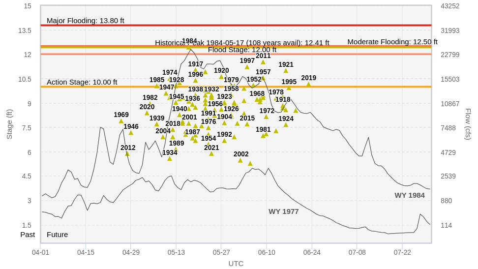
Forecasts of seasonal water supply are prepared monthly from January through June.
These forecasts are a useful indicator of either potential flood or drought conditions.
They are used by water managers for complex water management decisions.
Peak flow forecasts are used by river recreationists, flood control agencies, emergency service directors, wildlife managers
and anyone interested in the combined effect of watershed yield and human regulation on the actual (observed) in-stream maximum mean daily flows at a site.